
After a warm and humid evening across Southeast Michigan, residents should prepare for the potential of strong to severe thunderstorms developing Wednesday afternoon and evening.
Overnight Tuesday into early Wednesday morning will remain mostly dry, with partly to mostly cloudy skies and lows near 70°F. A warm, unstable air mass will linger into Wednesday as highs climb into the mid-80s — with some areas approaching 90°F.
However, an approaching frontal boundary is forecast to stall across the region on Wednesday, setting the stage for a volatile weather setup.
Severe Weather Outlook for Wednesday
The Storm Prediction Center has issued the following risk levels for severe thunderstorms:
- Enhanced Risk (Level 3 of 5): Livingston, Washtenaw, Lenawee, and Monroe counties.
- Slight Risk (Level 2 of 5): Much of Metro Detroit, including Wayne, Oakland, and Macomb counties.
- Marginal Risk (Level 1 of 5): Parts of Sanilac and St. Clair counties, including Sandusky and Port Huron.
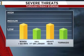
Main Threats
- Damaging Winds: Gusts could exceed 60–70 mph.
- Large Hail: Greater than one inch in diameter.
- Heavy Rain: Localized flooding possible.
- Tornadoes: An isolated tornado or two cannot be ruled out.
Storms are expected to develop in the afternoon and linger into the evening hours, with the strongest activity likely between 3 p.m. and 10 p.m. Wednesday night will remain mostly cloudy, with storms tapering off before midnight. Lows will fall to the mid-60s.
Thursday Outlook
Conditions will improve by Thursday, with a mix of sun and clouds, lower humidity, and a high near 82°F as the region begins to dry out.
Residents are advised to stay weather-aware, have multiple ways to receive alerts, and secure any loose outdoor items ahead of potential severe winds.